
RESTORING BIODIVERSITY _ Nature-Positive Works across the Strath
‘Nature positive’ works across the Strath
Regional or local action to preserve, conserve or restore biodiversity in Strathnairn
WHAT IS NATURE POSITIVE?
Nature positive is a global goal to halt and reverse nature loss by 2030, and achieve full recovery by 2050, measured against a 2020 baseline. It means making measurable gains in the health, abundance, diversity and resilience of species, ecosystems, and natural processes. This concept goes beyond simply ‘doing less harm’ to actively enhancing nature and requires a shift in how governments, businesses and societies interact with the environment.
WHY ARE NATURE POSITIVE WORKS NEEDED?
The Scottish and UK Governments have declared twin global crises of Biodiversity Loss & Climate Change. With this there is a ‘call to action’ across government, economy, business, organisations and community, to act decisively, change practices and embrace solutions not only to arrest, but to go further and actively reverse both. www.gov.uk ‘A new international consensus is building around the urgent need to act decisively to address the twin crises of biodiversity loss and climate change together. Just like climate change, the loss of species and degradation of our natural environment is an existential threat to humanity. And just like climate change, the action needed is both urgent and transformative. That’s why the Scottish Government is clear that this is an emergency that requires an emergency response.’
For more information see: Scottish Biodiversity Strategy to 2045: Tackling the Nature Emergency in Scotland Published September 2023.
CURRENT POLICY & NATIONAL PLANNING FRAMEWORK 4 (NPF4)
Aligned to the global drive to net zero and nature restoration, the following long term or emerging projects in Strathnairn, illustrate by way of an ‘example’ of how nature positive outcomes can be achieved when local and regional action is taken and/or the community works together. These projects fully align with NPF4’s Core Objectives on ‘Nature Restoration’, and have a natural synergy with many other keys areas of government policy. NPF4_Nature Restoration
In common these works:
- Embody nature conservation or nature recovery;
- Improve human connection to nature;
- Align with the thinking of an economy and society which puts a value on nature.
Local or regional action supporting ‘Nature Positive’ outcomes in Strathnairn
Loch Ruthven Nature Reserve & RSPB
RSPB PROTECTING HABITATS, SAVING SPECIES AND HELPING TO END THE NATURE AND CLIMATE EMERGENCY  ‘Slavonian Grebes on Loch Ruthven’ | Copyright: Weedon’s World of Nature, 2022 LOCH RUTHVEN
 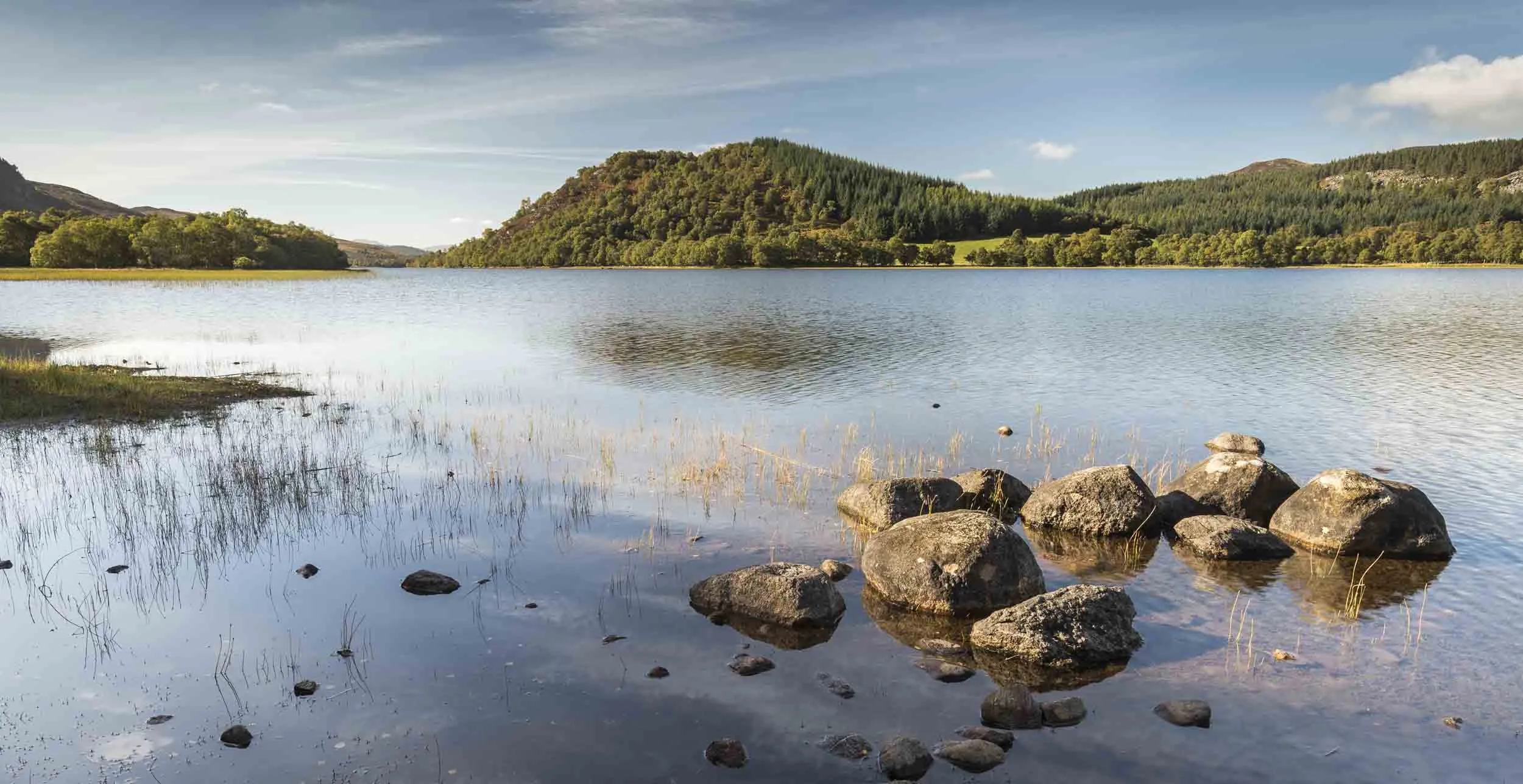 ‘Loch Ruthven Nature Reserve’ | Copyright: RSPB, 2012 See rspb.org.uk ‘Surrounded by birch woodlands and heather-clad hills, lochs don’t get much more picturesque or peaceful than Ruthven. The water here is fringed with sedge beds, making it a great place to see breeding Slavonian Grebes and Red-throated Divers. Visit Loch Ruthven nature reserve in early spring to get the best views of the rare Slavonian Grebe from the hide. The Grebe are looking their best from April in a beautiful red and golden plumage and ruby red eye – in the spring sunshine they shine like jewels on the loch. Lucky visitors may be in with a chance to see courting pairs dancing or nest building behaviour in the sedge beds from the hide. Glacial activity has left large, scarred boulders strewn around the loch edge. The woodlands and moorlands along the hide path and around the reserve are home to an array of lichens and fungi and a host of woodland birds including Willow Warbler, Long-tailed Tit and Tree Pipit. RSPB Scotland works to create the ideal conditions for wildlife at Loch Ruthven. Most of our efforts focus on the Slavonion Grebes who call the reserve home, as they are a Schedule 1 protected species. You can do your bit by staying 20m away from sedgebeds and Schedule 1 species while on the reserve, or water borne activities. This reduces the risk of disturbing the Slavonian Grebes and gives them extra protection during this important time of year. RSPB monitor the population and breeding success of the Slavonian Grebes and have a small team of volunteers who record sightings and Grebe behaviour from the hide. We are learning more about this mysterious species and the factors that affect the population and breeding. To protect the Grebes at Loch Ruthven, we regularly check for the presence of Mink on the loch and undertake work on the sedge beds to keep them in good condition for the Grebes’ floating nests. The remains of a crannog are located just off the reserve, and are sometimes visible when the loch waters are low. RSPB work with Historic Environment Scotland to protect the crannog.’ Extracted from RSPB website: RSPB Reserves_Loch Ruthven For more information contact: Loch Ruthven, B851, Inverness, Highland, IV2 6UA | 01463 715000 | nsro@rspb.org.uk
RAMSAR SITES IN SCOTLAND ‘Scotland has 51 Ramsar sites designated as internationally important wetlands, covering a total area of about 313,000 hectares. Most Ramsar sites in Scotland are linked to the European site network – either as a Special Protection Area (SPA) or Special Area of Conservation (SAC). All are underpinned by Sites of Special Scientific Interest (SSSIs). These sites may be of importance for their wide variety of waterbirds, bogs, lochs, coastal wetlands and other water-dependent habitats and species. Learn about designating Ramsar sites on the Ramsar website.’
PROTECTION OF RAMSAR SITES ‘It is Scottish Government policy that all features of Ramsar sites must be treated as though they are features of European sites (Special Protection Areas (SPAs) and Special Areas of Conservation (SACs)) for the purposes of land use change decision making. This means that plans or projects on or affecting a feature of a Ramsar site must be subject to an appraisal similar to Habitats Regulations Appraisal (HRA) for European site features, as well as a HRA for any European site features. We also include Ramsar sites in our Site Condition Monitoring programme. If you manage land or water within a Ramsar site, you may be able to get funding to help you carry out appropriate conservation management. Find out about the Scottish Rural Development Programme (SRDP).’ Extracted from Nature Scot. See Nature Scot_Professional Advice on RAMSAR Sites
LOCH RUTHVEN | CLASSIFICATIONS, DOCUMENTATION & MAPPING
- Loch Ruthven RAMSAR https://sitelink.nature.scot/site/8444
- Loch Ruthven Site of Scientific Interest (SSI) https://sitelink.nature.scot/site/1047
- Loch Ruthven Special Area of Conservation (SCA) https://sitelink.nature.scot/site/8306
- Loch Ruthven Special Protection Area (SPA) https://sitelink.nature.scot/site/8538
For related information see |
- Nature Scot https://www.nature.scot/
- John Muir Trust https://www.johnmuirtrust.org/
- RSPB https://www.rspb.org.uk/
02 | MILTON AND SCHOOL WOODS & STRATHNAIRN COMMUNITY WOODLANDS
COMMUNITY-OWNED AND MANAGED WOODLANDS IN STRATHNAIRN; ESTABLISHED 2003. ‘Our Trustees look after the wellbeing of both Milton and School woods in Farr with a clear goal of increasing biodiversity whist providing safe access to our community. School wood offers a wonderful facility for the local primary school to explore and learn right on their doorstep. School wood also has a pavilion that can be booked for your own private function.’ Extracted from Strathnairn Community Woodlands. See https://www.strathnairncw.org.uk/ STRATHNAIRN FOREST SHELTER  ‘Strathnairn Forest Shelter’ | Copyright: Neil Sutherland Architects ‘ A forest shelter for Strathnairn Community Woodland group built within the forest for use by the local school and community members. The shelter comprises a covered enclosed element with extensive decked areas. Large garage-type doors open up to allow access between the deck and covered space. The timber for the shelter was supplied by Strathnairn Community Woodland from our own woodland, and milled nearby using a portable saw. The main structural frame is Douglas Fir with simple bolted connections. The deck, cladding and handrails are made from more durable larch. The roof is finished with sedum on a waterproof rubber membrane. The shelter is not insulated, and is intended for use only when weather conditions allow.’ Extracted from Neil Sutherland Architects (now MAKAR). See Neil Sutherland Architects For related information see |
- Community Woodlands Association https://www.communitywoods.org/
- DTAS DTAS Factsheet on Community Woods
- Woodland Trust Woodland Trust on Community Woods
03 | OLD WALLED GARDEN / FARR ESTATE & FEARNAG GROWERS
A COMMUNITY GROWING PROJECT IN THE HIGHLANDS; ESTABLISHED 2016.
For related information see |
- Get Growing Scotland https://getgrowingscotland.org/
- Highland Good Food Partnership Get Your Community Growing
- RHS & Community Gardening RHS on Community Gardening
04 | STRATHNAIRN DARK SKIES & STRATHNAIRN STARGAZERS
 Photo: ‘Night Sky at Loch Ruthven’, David Huxtable Reid
COMMUNITY-BASED APPLICATION / WORKS IN 2025; FOLLOWING ON FROM EARLIER WORK IN 2017.
Whether you are an amateur astronomer, experienced telescopist, aurora hunter or a nocturnal adventurer, Strathnairn and its associated dark skies are there to be enjoyed by all. With its unique remote rural setting – bordering the Monadhliath Mountains – the Strath’s topography (along with the community’s past rejection of streetlighting) means the area remains free from light pollution associated with Inverness (at just 8 miles away) and the neighbouring A9. DARK SKIES INTERNATIONAL & STRATHNAIRN COMMUNITY’S APPLICATION In 2025, to ensure this continues to be the case, and following on from the community’s earlier and ongoing work from 2017 – as a community – we are currently in the process of applying for the Strathnairn Dark Sky Park, through the Dark Skies International (DSI). This is to ensure our dark skies are rightfully recognised; and continue to be protected for generations to come.
- Strathnairn’s Dark Skies_Information Leaflet May 2025
- Modulo Universe article on ‘Dark Skies At Strathnairn’
DARK SKIES INTERNATIONAL
DarkSky International restores the nighttime environment and protects communities from the harmful effects of light pollution through outreach, advocacy, and conservation. For more information on Dark Skies International see DarkSky International | Protecting the night skies for present and future generations INITIAL SAMPLING & PAST SURVEYS Initial sampling of existing data from established survey points shows that Strathnairn’s Dark Skies Park will likely be ‘Bortle 3 | Rural Sky Classification’ on The Bortle Scale (which ranges from Class 1 / Excellent Dark Sky site / no light pollution > Class 9 / Inner city site / with light pollution). Bortle 3 Classification characteristics include the Milky Way still appearing complex; with zodiacal light striking in spring and autumn, colour still visible etc. Why Strathnairn is seeking DSI Classification? To recognise our dark skies and protect our environment; as light pollution disrupts wildlife, impacts human health, wastes money and energy, contributes to climate change, and blocks our view of the universe.
JOHN MUIR TRUST & MONADHLIATH MOUNTAINS
The John Muir Trust is a leading voice for the UK’s wild places; dedicated to the conservation, protection and restoration of the UK’s wild places, for the benefit of all.
The John Muir Trust have confirmed their support for Strathnairn’s Application to DSI.
STRATHNAIRN HERITAGE ASSOCIATION & PROTECTION OF NATURAL HERITAGE IN THE STRATH
Strathnairn Heritage Association, is a registered charity (SC052263). SHA are a small but enthusiastic group of volunteers, dedicated to researching the history of our strath. See Strathnairn Heritage Association | A Brief History For an understanding of the biodiversity and natural heritage to be protected across Strathnairn see Strathnairn Heritage Association | Natural Heritage Or the work of Findhorn Watershed’s ‘Human Ecology Researcher in Residence’ (plus Strathnairn resident) Raghnaid Sandilands in mapping Gaelic place names to wild spaces and natural heritage AN SEALBHANAICH – AN UNMAPPED PLACENAME IN STRATHNAIRN — a’ siubhal nam frith-rathadan
HIGHLAND ASTRONOMICAL SOCIETY & JIM SAVAGE-LOWDEN OBSERVATORY, CULLODEN. ESTABLISHED 2008. For related information see |
-
- Highlands Astronomical Society Highlands Astronomical Society | Highlands Astronomical Society
- Jim Savage-Lowden Observatory Doors Open Day on the Jim Savage-Lowden Observatory
- Highland Astronomy | Modulo Universe Modulo Universe
- Capturing the night sky | Gael Hillyard Gael Hillyard on Night Skies
- Royal Observatory, Edinburgh Royal Observatory, Edinburgh
- Dark Skies International DSI
05 | UPPER RIVER NAIRN REPAIR & ABERARDER ESTATE
PROJECT COMPLETED IN APRIL 2018, WITH MONITORING STILL ONGOING.
‘Restoration of channel and floodplain processes at Aberarder in the upper Nairn catchment were conducted at a catchment scale, extending across 60% of the length of the river at the downstream limit of the site. Following a ‘process-based’ approach, an ‘assisted recovery’ design strategy was adopted, permitting the river to self-adjust towards a quasi-stable ‘dynamic equilibrium’ morphological condition. The aim was to reinstate a greater potential for the development of lateral channel variability (through the evolution of alluvial bar forms and associated bank erosion processes) and connectivity with wetland/ floodplain environments. Outcomes: The work has resulted in rapid evolution of the site to a condition of a naturally self-sustaining and physically diverse river environment with associated ecological responses. Removal of embankments and wetland establishment has increased floodplain inundation within the river corridor, providing direct benefits to physical and ecological processes but also improvements to agriculture through reduced flooding and improved drainage. There has been a marked response to the works in freshwater biota, including fish (salmonids) and invertebrates.’ Extracted from the Aberarder Estate. See River Nairn Restoration Summary 2019
RIVER NAIRN | CONTEXT
‘River Nairn, located in the Scottish Highlands south and east of Inverness, flows through mountains, moorland and farmland to the Moray Firth, approximately 36 miles away. It is an essentially rural river, with the largest settlement, Nairn (pop. 8,600), at the river mouth.
The word ‘Nairn’ is from the Gaelic Uisge-Nearn, ‘the river of alders,’ and many of the banks in the middle reaches are shaded by these beautiful trees. The River Nairn arises near Carn Ghriogair in the Monadhliath Mountains at approximately 800m above sea level. As it flows mainly northeast out to the Moray Firth, it passes through Strathnairn and past Culloden Moor, site of the famous battle of 1746. The main tributaries are the River Brin, River Farnack, Craggie Burn and Cawdor Burn although there are several other smaller burns. Loch Duntelchaig is the only major loch draining into the Nairn although some smaller still waters are present. Loch Duntelchaig is also used for public water supply.’ Extracted from Findhorn, Nairn and Lossie Rivers Trust https://www.fnlrt.org.uk/our-catchments/nairn/
THE FINDHORN, NAIRN AND LOSSIE RIVERS TRUST & THE FINDHORN WATERSHED INITIATIVE
‘Catalysed by the global drive towards net zero and ecosystem restoration, the Findhorn Watershed Initiative brings together the watershed’s land owners, land managers, communities, businesses, and other river users across an area of 1300km2 for the benefit of future generations.
Led by local environmental conservation intermediary – The Findhorn, Nairn and Lossie Rivers Trust – the Findhorn Watershed Initiative was created as a direct response to the Trust’s 2021-26 Management Plan, which prioritises climate mitigation and habitat restoration, and is inspired by a bioregioning approach.’
Extracted from Findhorn Watershed Initiative https://findhornwatershed.com/ For related information see |
- Findhorn, Nairn & Lossie Rivers Trust https://www.fnlrt.org.uk/
- The River Restoration Centre https://www.therrc.co.uk/
- Scottish Environmental Protection Agency (SEPA) https://www.sepa.org.uk/